
What we do
The Consortium develops a Global Gravity-based Groundwater Product (G3P) that will show groundwater storage variations with global coverage and monthly resolution from 2002 until present.
How do we do that?
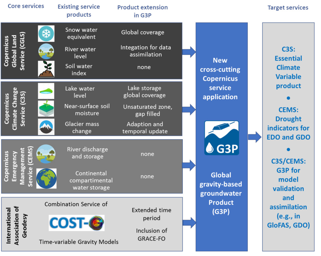
This is done by a cross-cutting combination of GRACE and GRACE-FO satellite gravity data with water storage data that are based on the existing portfolio of the Copernicus services.
What is GRACE/GRACE-FO and Copernicus?
GRACE [1] was a satellite mission (2002-2017) to measure the Earth’s gravity field and its variation in space and time. It consisted of two satellites following each other on the same orbital track. At an orbital altitude of about 450 km, the distance between the two GRACE satellites was on average 220 km, but constantly changing due to the varying attraction of masses on the surface and inside the Earth. Repeated observations by this constellation ultimately yield changes in the mass distribution, such as changes in the distribution of water stored on and below the Earth's surface.
GRACE Follow-On (GRACE-FO) [2] has been launched into its Earth orbit in 2018 and provides continuity fo the GRACE data set.
Copernicus [3] is the European Union's Earth Observation Programme that offers information services based on satellite Earth Observation and in-situ data.
Ok, but I still don’t understand how this is related to groundwater…
GRACE/GRACE-FO are able to observe spatial and temporal variations of total water storage (TWS) on all continental areas of the Earth.
TWS, as observed by GRACE/GRACE-FO, is the sum of the variations of several storage compartments, including groundwater:
TWS = groundwater + glaciers + snow + soil moisture + storage in surface water bodies
If we estimate variations of TWS from GRACE/GRACE-FO and water storage variations of glaciers, snow, soil moisture and surface water bodies from other Earth observation satellites or models, we can calculate the variations in groundwater storage by the following subtraction process:
I have the feeling that I have seen this before.
You are right, this approach is not new. It has been used in numerous studies for different areas worldwide. What makes G3P different is that it is global in extent and utmost based on satellite observation data, instead of simulated data.
Most of the water storage data needed for the subtraction process are at least partially available from existing Copernicus service products. These products are based on satellite observations and partly on simulation results of hydrological models. The basic concept of G3P is to bring these Copernicus data sets together, develop them further where necessary and merge the observation-based and simulations-based data sets where necessary to achieve full spatial and temporal coverage.
Our cross-cutting G3P service combination and extension approach is illustrated below (click to enlarge).